China launches three commercial remote sensing satellites

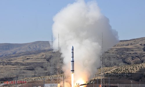
A remote sensing satellite of the Jilin-1 satellite series successfully launches Tuesday in North China's Shanxi Province. Photo: VCG
China launched three remote sensing satellites Tuesday from the Taiyuan Satellite Launch Center in North China's Shanxi Province.
The three satellites - Jilin-1 04, Jilin-1 05 and Jilin-1 06 - carried cameras designed to improve observation capability for the remote sensing industry.
It was the third launch of the Jilin-1 satellite family, a remote sensing system of more than 60 satellites developed by Chang Guang Satellite Technology Company Ltd based in Changchun, Northeast China's Jilin Province.
The system will be used for wide imaging, video imaging and multispectral imaging. Remote sensing data will serve agencies and commercial customers.
Tuesday's satellites were carried by a Long March-6 rocket, a new generation of China's liquid-fueled carrier rocket developed by China Aerospace Science and Technology Corporation. The launch is the second mission of the Long March-6 and the 255th flight carried out with the Long-March series of carrier rockets.
Jilin-1, the country's first self-developed remote sensing satellite for commercial use, was sent into space in October 2015 from the Jiuquan Satellite Launch Center in Northwest China's Gansu Province.
Jilin, one of the country's oldest industrial bases, is developing its satellite industry as a new economic engine. The province plans to launch 60 satellites by 2020 and 137 by 2030.
Your Comment
Name E-mailRelated News
-
;
Based in Lhasa, Tibet Vista is a Tibet travel agency that specialized in Tibet permit, and Tibet tours for both private and group travelers at a local price!
•4 Days Lhasa City Group Tour from USD 460 •8 Days Everest Base Camp Group Tour from USD 850 •15 Days Mt.Kailash Group Tour from USD 1780 •2016 Tibet Train Tours from Beijing, Shanghai, Chengdu, Xining,etc


